Geolocate

Llorente topographic map

Click on the map to display elevation.

About this map

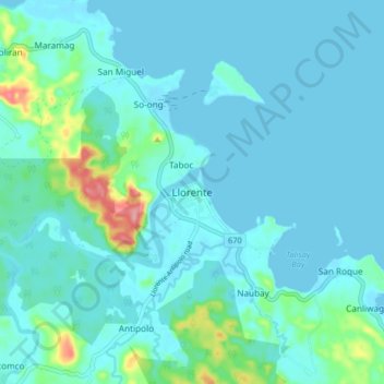
Name: Llorente topographic map, elevation, terrain.

Location: Llorente, Eastern Samar, Eastern Visayas, 6803, Philippines (11.37141 125.50590 11.45141 125.58590)

Average elevation: 56 ft

Minimum elevation: 0 ft

Maximum elevation: 404 ft

Other topographic maps

Click on a map to view its topography, its elevation and its terrain.

Homonhon Island

Philippines > Eastern Samar > Cagusu-an

Average elevation: 89 ft

Oras

Philippines > Eastern Samar > Jipapad

Average elevation: 121 ft

Suribao River

Philippines > Eastern Samar > Banuyo

Average elevation: 344 ft

Llorente River

Philippines > Eastern Samar > Can-ato

Average elevation: 243 ft

Dolores River

Philippines > Eastern Samar

Average elevation: 341 ft

Gear up for your next adventure:

Backpacking Tent - Lightweight and durable tent for multi‑day hikes
🥤Water Filter Bottle - All‑in‑one filter bottle for safe hydration
🛰️Handheld GPS Units - Professional satellite navigators for precise backcountry mapping
🪶Fire Starter Kit - Reliable fire starter for survival and camping
🖼️Topo Map Wall Art - Decorative topographic prints of famous peaks and regions

As an Amazon Associate, this site earns from qualifying purchases at no extra cost to you.