
Make a donation
Gear up for your next adventure:
As an Amazon Associate, this site earns from qualifying purchases at no extra cost to you.
Hagerstown topographic map
Click on the map to display elevation.
Make a donation
Gear up for your next adventure:
As an Amazon Associate, this site earns from qualifying purchases at no extra cost to you.
Hagerstown
Terrain surrounding Hagerstown consists of flat land at an elevation of roughly 1000 feet above sea level that is used primarily for agriculture.
Make a donation
Gear up for your next adventure:
As an Amazon Associate, this site earns from qualifying purchases at no extra cost to you.
About this map
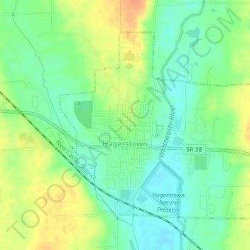
Name: Hagerstown topographic map, elevation, terrain.
Location: Hagerstown, Wayne County, Indiana, United States (39.90306 -85.17084 39.92317 -85.14325)
Average elevation: 1,024 ft
Minimum elevation: 968 ft
Maximum elevation: 1,099 ft
Wayne County trails, hiking, mountain biking, running and outdoor activities
Make a donation
Gear up for your next adventure:
As an Amazon Associate, this site earns from qualifying purchases at no extra cost to you.
Other topographic maps
Click on a map to view its topography, its elevation and its terrain.