
Make a donation
Gear up for your next adventure:
As an Amazon Associate, this site earns from qualifying purchases at no extra cost to you.
Hillsgrove topographic map
Click on the map to display elevation.
Make a donation
Gear up for your next adventure:
As an Amazon Associate, this site earns from qualifying purchases at no extra cost to you.
About this map
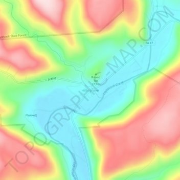
Name: Hillsgrove topographic map, elevation, terrain.
Average elevation: 1,289 ft
Minimum elevation: 804 ft
Maximum elevation: 1,909 ft
Sullivan County trails, hiking, mountain biking, running and outdoor activities
Make a donation
Gear up for your next adventure:
As an Amazon Associate, this site earns from qualifying purchases at no extra cost to you.
Other topographic maps
Click on a map to view its topography, its elevation and its terrain.
Worlds End State Park
United States > Pennsylvania > Sullivan County > Forks Township
There was even a dispute as to the proper name of the area. Some people called it Worlds End, others Whirl's Glen, and still others Whirls End. The first name arose from the topography of the place. Seven mountain ranges converge on the point and one does receive the sensation of being at the ultimate ends of…
Average elevation: 1,604 ft
Elk Lake
United States > Pennsylvania > Sullivan County > Elkland Township
Average elevation: 1,654 ft
Make a donation
Gear up for your next adventure:
As an Amazon Associate, this site earns from qualifying purchases at no extra cost to you.