
Thank you for supporting this site ❤️
Make a donation
Make a donation
Gear up for your next adventure:
As an Amazon Associate, this site earns from qualifying purchases at no extra cost to you.
Siviez topographic map
Click on the map to display elevation.
Thank you for supporting this site ❤️
Make a donation
Make a donation
Gear up for your next adventure:
As an Amazon Associate, this site earns from qualifying purchases at no extra cost to you.
About this map
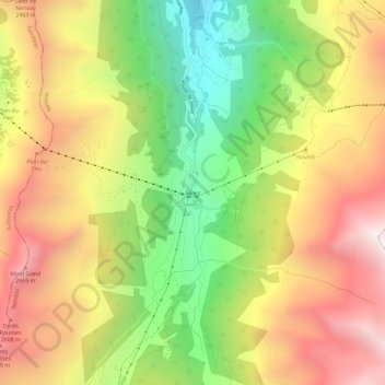
Name: Siviez topographic map, elevation, terrain.
Location: Siviez, Nendaz, Conthey, Wallis, 1997, Switzerland (46.11561 7.29644 46.15561 7.33644)
Average elevation: 7,041 ft
Minimum elevation: 4,711 ft
Maximum elevation: 9,314 ft
Thank you for supporting this site ❤️
Make a donation
Make a donation
Gear up for your next adventure:
As an Amazon Associate, this site earns from qualifying purchases at no extra cost to you.