
Make a donation
Gear up for your next adventure:
As an Amazon Associate, this site earns from qualifying purchases at no extra cost to you.
Saint-Gingolph topographic map
Click on the map to display elevation.
Make a donation
Gear up for your next adventure:
As an Amazon Associate, this site earns from qualifying purchases at no extra cost to you.
About this map
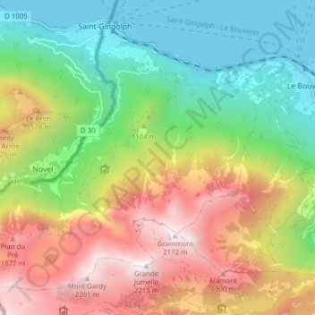
Name: Saint-Gingolph topographic map, elevation, terrain.
Location: Saint-Gingolph, Monthey, Wallis, 1898, Switzerland (46.34711 6.77063 46.42716 6.85480)
Average elevation: 2,418 ft
Minimum elevation: 1,201 ft
Maximum elevation: 7,126 ft
Make a donation
Gear up for your next adventure:
As an Amazon Associate, this site earns from qualifying purchases at no extra cost to you.
Other topographic maps
Click on a map to view its topography, its elevation and its terrain.
Torgon
Switzerland > Wallis > Monthey
Torgon is a village in the Swiss Alps, located in the canton of Valais. It lies on the western part of the canton, in the region of the Chablais, at an altitude of 1,085 metres. The village sits on a sunny terrace overlooking the Rhone valley, above Vionnaz. Politically Torgon belongs to the latter town.
Average elevation: 2,900 ft
Lac Vert
Switzerland > Wallis > Monthey > Val-d'Illiez
Lake Vert is a lake in the Chablais region of the canton of Valais, Switzerland. The lake is located in the municipality of Val-d'Illiez, at an elevation of 1972 metres, near the border with France. Lac de Chésery lies 600 metres north.
Average elevation: 6,339 ft
Make a donation
Gear up for your next adventure:
As an Amazon Associate, this site earns from qualifying purchases at no extra cost to you.
Lac Vert
Switzerland > Wallis > Monthey > Val-d'Illiez
Lake Vert is a lake in the Chablais region of the canton of Valais, Switzerland. The lake is located in the municipality of Val-d'Illiez, at an elevation of 1972 metres, near the border with France. Lac de Chésery lies 600 metres north.
Average elevation: 6,339 ft
Dents du Midi
Switzerland > Wallis > Monthey > Val-d'Illiez
The Dents du Midi are situated on the border between the communes of Val-d'Illiez and Evionnaz. The north face rises above the Val d'Illiez while the south face overlooks the Lac de Salanfe, an artificial reservoir. The ridge of the chain is situated at an altitude varying between 2,997 and 3,258 meters (9,833…
Average elevation: 8,005 ft