
Schwedenschanze topographic map
Interactive map
Click on the map to display elevation.
About this map
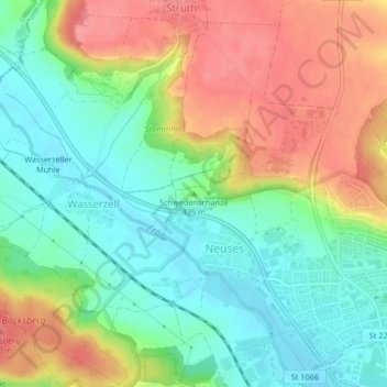
Name: Schwedenschanze topographic map, elevation, terrain.
Location: Schwedenschanze, Ansbach, Bayern, 91522, Deutschland (49.31856 10.54989 49.31866 10.54999)
Average elevation: 1,434 ft
Minimum elevation: 1,316 ft
Maximum elevation: 1,588 ft
Other topographic maps
Click on a map to view its topography, its elevation and its terrain.
Bernhardswinden
Deutschland > Bayern > Ansbach
Bernhardswinden, Ansbach, Bayern, 91522, Deutschland
Average elevation: 1,545 ft
Strüth
Deutschland > Bayern > Ansbach
Strüth, Ansbach, Bayern, 91522, Deutschland
Average elevation: 1,480 ft
Brodswinden
Deutschland > Bayern > Ansbach > Brodswinden
Brodswinden, Ansbach, Bayern, 91595, Deutschland
Average elevation: 1,499 ft