
Make a donation
Gear up for your next adventure:
As an Amazon Associate, this site earns from qualifying purchases at no extra cost to you.
Bernhardswinden topographic map
Click on the map to display elevation.
Make a donation
Gear up for your next adventure:
As an Amazon Associate, this site earns from qualifying purchases at no extra cost to you.
Bernhardswinden
Gottfried Stieber beschrieb den Ort in seinem 1761 erschienenen Werk „Historische und topographische Nachrichten von dem Fürstenthum Brandenburg-Onolzbach“ folgendermaßen.
Make a donation
Gear up for your next adventure:
As an Amazon Associate, this site earns from qualifying purchases at no extra cost to you.
About this map
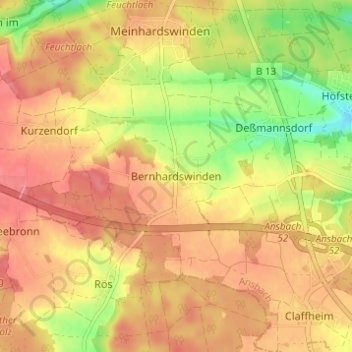
Name: Bernhardswinden topographic map, elevation, terrain.
Location: Bernhardswinden, Ansbach, Bayern, 91522, Deutschland (49.24398 10.54630 49.28398 10.58630)
Average elevation: 1,545 ft
Minimum elevation: 1,385 ft
Maximum elevation: 1,640 ft
Make a donation
Gear up for your next adventure:
As an Amazon Associate, this site earns from qualifying purchases at no extra cost to you.