
Make a donation
Gear up for your next adventure:
As an Amazon Associate, this site earns from qualifying purchases at no extra cost to you.
Stekene topographic map
Click on the map to display elevation.
Make a donation
Gear up for your next adventure:
As an Amazon Associate, this site earns from qualifying purchases at no extra cost to you.
Stekene
Stekene ligt in het Waasland en in Zandig Vlaanderen. Het gebied is rijk aan bos. De gemeente ligt pal ten zuiden van de Belgisch-Nederlandse grens en de hoogte bedraagt 5-7 meter, met stuifzandruggen tot 10 meter hoogte.
Make a donation
Gear up for your next adventure:
As an Amazon Associate, this site earns from qualifying purchases at no extra cost to you.
About this map
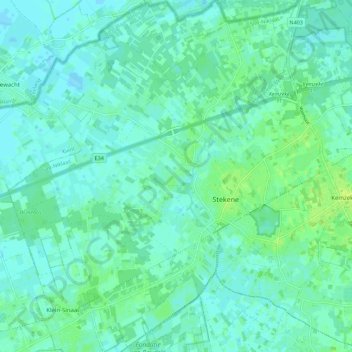
Name: Stekene topographic map, elevation, terrain.
Location: Stekene, Sint-Niklaas, Oost-Vlaanderen, Vlaanderen, 9190, België (51.17598 3.97773 51.24568 4.06988)
Average elevation: 13 ft
Minimum elevation: -7 ft
Maximum elevation: 39 ft
Make a donation
Gear up for your next adventure:
As an Amazon Associate, this site earns from qualifying purchases at no extra cost to you.
Other topographic maps
Click on a map to view its topography, its elevation and its terrain.
Make a donation
Gear up for your next adventure:
As an Amazon Associate, this site earns from qualifying purchases at no extra cost to you.