
Make a donation
Gear up for your next adventure:
As an Amazon Associate, this site earns from qualifying purchases at no extra cost to you.
Kalesija topographic map
Click on the map to display elevation.
Make a donation
Gear up for your next adventure:
As an Amazon Associate, this site earns from qualifying purchases at no extra cost to you.
About this map
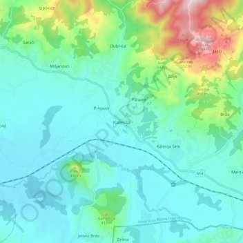
Name: Kalesija topographic map, elevation, terrain.
Average elevation: 1,073 ft
Minimum elevation: 745 ft
Maximum elevation: 2,313 ft
Make a donation
Gear up for your next adventure:
As an Amazon Associate, this site earns from qualifying purchases at no extra cost to you.
Other topographic maps
Click on a map to view its topography, its elevation and its terrain.
Rama
Bosnia and Herzegovina > Federation of Bosnia and Herzegovina > Gračanica
Average elevation: 2,385 ft
City of Sarajevo
Bosnia and Herzegovina > Federation of Bosnia and Herzegovina
Average elevation: 2,657 ft
Make a donation
Gear up for your next adventure:
As an Amazon Associate, this site earns from qualifying purchases at no extra cost to you.
Velež
Bosnia and Herzegovina > Federation of Bosnia and Herzegovina > Town of Zavidovići
Average elevation: 1,759 ft
Boračko jezero
Bosnia and Herzegovina > Federation of Bosnia and Herzegovina > Town of Konjic > Jezero
It lies at the northeastern foot of the mountain Prenj, at an altitude 397 m. From the west it is surrounded by steep forested mountain slopes of Crna Gora (Black Mountain, 1343 m), and from the east by Tranjine (1055 m). The lake basin was created in the Boračka draga, during the expansive process of glacial…
Average elevation: 2,185 ft
Bosnian-Podrinje Canton Goražde
Bosnia and Herzegovina > Federation of Bosnia and Herzegovina
Average elevation: 2,877 ft
Make a donation
Gear up for your next adventure:
As an Amazon Associate, this site earns from qualifying purchases at no extra cost to you.
West Herzegovina Canton
Bosnia and Herzegovina > Federation of Bosnia and Herzegovina
This region, before the war, was one of the poorest regions in BiH. Today it is one of the richest. Despite the canton's small size in area, its agricultural sector is important. In the canton, 30,000 ha (120 sq miles) is used for agriculture; 84,000 ha (320 sq miles) is forest. Around 6,000 ha of arable land…
Average elevation: 1,946 ft
Centar Municipality
Bosnia and Herzegovina > Federation of Bosnia and Herzegovina > City of Sarajevo
Average elevation: 2,812 ft