Geolocate

Arandas topographic map

Click on the map to display elevation.

About this map

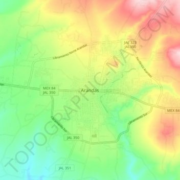
Name: Arandas topographic map, elevation, terrain.

Location: Arandas, Región Altos Sur, Jalisco, 47183, Mexico (20.66587 -102.38791 20.74587 -102.30791)

Average elevation: 6,804 ft

Minimum elevation: 6,447 ft

Maximum elevation: 7,293 ft

Other topographic maps

Click on a map to view its topography, its elevation and its terrain.

Arandas

Mexico > Jalisco > Arandas

Average elevation: 6,663 ft

Gear up for your next adventure:

🪶Thermal Camp Blanket - Extra warmth for cold nights
📻Weather Alert Radios - Stay informed of storm risks while off-the-grid
🎒Gear Packing Cubes - Organize your backpack efficiently
🪶Wildlife Field Guides - Learn animal tracking and species ID
🧴Hand Sanitizer - Keep hands clean while hiking

As an Amazon Associate, this site earns from qualifying purchases at no extra cost to you.