
Make a donation
Gear up for your next adventure:
As an Amazon Associate, this site earns from qualifying purchases at no extra cost to you.
Holzleiten topographic map
Click on the map to display elevation.
Make a donation
Gear up for your next adventure:
As an Amazon Associate, this site earns from qualifying purchases at no extra cost to you.
About this map
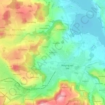
Name: Holzleiten topographic map, elevation, terrain.
Average elevation: 1,634 ft
Minimum elevation: 1,444 ft
Maximum elevation: 1,932 ft
Make a donation
Gear up for your next adventure:
As an Amazon Associate, this site earns from qualifying purchases at no extra cost to you.
Other topographic maps
Click on a map to view its topography, its elevation and its terrain.
Waginger See
Deutschland > Bayern > Landkreis Traunstein > Waging am See > Fisching
Der See friert auch heute noch in strengen Wintern zu. Bis in die 1960er Jahre war das fast alljährlich der Fall. Der Waginger See friert wegen der höheren Durchschnittstemperatur und wohl auch wegen größerer Strömungen einige Tage später zu als der Tachinger See. Nur bei lang andauernden und extrem…
Average elevation: 1,522 ft