
Make a donation
Gear up for your next adventure:
As an Amazon Associate, this site earns from qualifying purchases at no extra cost to you.
Denver topographic map
Click on the map to display elevation.
Make a donation
Gear up for your next adventure:
As an Amazon Associate, this site earns from qualifying purchases at no extra cost to you.
About this map
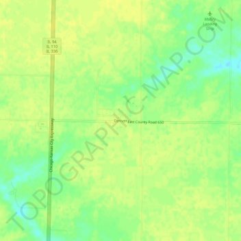
Name: Denver topographic map, elevation, terrain.
Location: Denver, Hancock County, Illinois, 62316, United States (40.27060 -91.12708 40.31060 -91.08708)
Average elevation: 669 ft
Minimum elevation: 627 ft
Maximum elevation: 686 ft
Make a donation
Gear up for your next adventure:
As an Amazon Associate, this site earns from qualifying purchases at no extra cost to you.
Other topographic maps
Click on a map to view its topography, its elevation and its terrain.
Nauvoo
United States > Illinois > Hancock County
Because most of the city is well above flood level, Nauvoo has not historically had problems when the Mississippi river has risen. In both the floods of 1993 and 2008, very little damage was sustained within city limits. Topography maps show a unique feature of Nauvoo with main street starting at the edge of…
Average elevation: 584 ft
Make a donation
Gear up for your next adventure:
As an Amazon Associate, this site earns from qualifying purchases at no extra cost to you.
Nauvoo
United States > Illinois > Hancock County
Because most of the city is well above flood level, Nauvoo has not historically had problems when the Mississippi River has risen. In both the floods of 1993 and 2008, very little damage was sustained within city limits. Topography maps show a unique feature of Nauvoo with main street starting at the edge of…
Average elevation: 584 ft