Geolocate

Costa topographic map

Click on the map to display elevation.

About this map

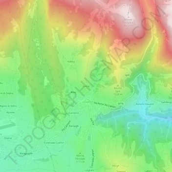
Name: Costa topographic map, elevation, terrain.

Location: Costa, Gallio, Vicenza, Veneto, 36032, Italia (45.87621 11.52621 45.91621 11.56621)

Average elevation: 3,891 ft

Minimum elevation: 2,897 ft

Maximum elevation: 5,282 ft

Gear up for your next adventure:

📻Weather Alert Radios - Stay informed of storm risks while off-the-grid
🏫Relief Map Kits - Hands-on tools for teaching landforms and elevation
🦟Ultrasonic Repellers - Create a bug-free zone at your camp or rest stop
🧭GPS Watch Accessories - Bands and chargers for GPS watches
🔌USB Car Charger - Car charger for on‑the‑go power needs

As an Amazon Associate, this site earns from qualifying purchases at no extra cost to you.