Geolocate

Batino topographic map

Click on the map to display elevation.

About this map

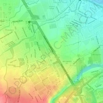
Name: Batino topographic map, elevation, terrain.

Location: Batino, Calamba, Laguna, Calabarzon, 4027, Philippines (14.19430 121.12562 14.21292 121.13964)

Average elevation: 171 ft

Minimum elevation: 30 ft

Maximum elevation: 338 ft

Other topographic maps

Click on a map to view its topography, its elevation and its terrain.

Bucal

Philippines > Laguna > Calamba

Average elevation: 72 ft

88 Spa & Resort

Philippines > Laguna > Calamba

Average elevation: 272 ft

ASN Ph2 Park

Philippines > Laguna > Calamba

Average elevation: 436 ft

Bucal Reservoir

Philippines > Laguna > Calamba

Average elevation: 138 ft

Calamba Town Plaza

Philippines > Laguna > Calamba

Average elevation: 36 ft

Gear up for your next adventure:

🎒Day Hiking Backpack - Lightweight backpack perfect for day trips and outdoor adventures
🎒Waterproof Dry Bags - Keep your electronics and maps dry inside your pack
GPS Sports Watch - GPS watch for running, hiking and training
🧼Biodegradable Camping Soap - Eco‑friendly soap for outdoor hygiene
🎒Gear Packing Cubes - Organize your backpack efficiently

As an Amazon Associate, this site earns from qualifying purchases at no extra cost to you.