Geolocate

Imperia topographic map

Click on the map to display elevation.

About this map

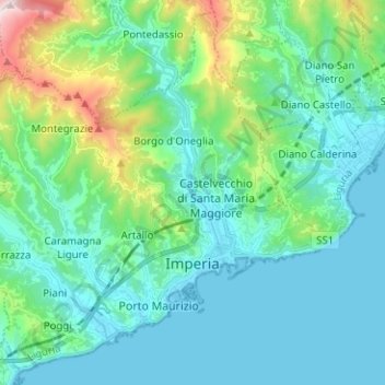
Name: Imperia topographic map, elevation, terrain.

Location: Imperia, Provincia di Imperia, Liguria, 18100, Italy (43.86061 7.94636 43.94547 8.07205)

Average elevation: 433 ft

Minimum elevation: -3 ft

Maximum elevation: 2,310 ft

Gear up for your next adventure:

🏥Hiking First Aid Kits - Comprehensive medical kits for remote trail injuries
🎒Trekking Poles - Sturdy poles for balance and stability on rough terrain
🏔️Mountain Trail Maps - High‑detail maps for popular peaks
🎒Waterproof Dry Bags - Keep your electronics and maps dry inside your pack
🔌USB Car Charger - Car charger for on‑the‑go power needs

As an Amazon Associate, this site earns from qualifying purchases at no extra cost to you.