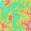
Ballarat topographic map
Click on the map to display elevation.
Ballarat
Ballarat has a moderate oceanic climate (Köppen climate classification Cfb) with four distinct seasons. Its elevation, ranging between 400 and 630 metres (1,310 and 2,070 feet) above sea level, causes its mean monthly temperatures to tend to be on average 3 to 5 °C (5 to 9 °F) below those of Melbourne, especially in winter. The mean daily maximum temperature for January is 25.1 °C (77 °F), while the mean minimum is 10.9 °C (52 °F). In July, the mean maximum is 10.0 °C (50 °F); average July minimum is 3.2 °C (38 °F). Ballarat has 55.2 clear days annually, with the majority in summer and early autumn. Ballarat has very rainy winters.
About this map
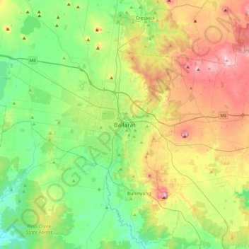
Name: Ballarat topographic map, elevation, terrain.
Location: Ballarat, Victoria, 3350, Australia (-37.72230 143.70056 -37.40230 144.02056)
Average elevation: 1,542 ft
Minimum elevation: 1,066 ft
Maximum elevation: 2,428 ft
Other topographic maps
Click on a map to view its topography, its elevation and its terrain.
City of Melbourne
Melbourne's topography is characterized by a diverse landscape that transitions from flat coastal plains to rolling hills and mountainous regions. The city is situated at the northern end of Port Phillip Bay, where the terrain is predominantly flat, facilitating urban development. As one moves eastward, the…
Average elevation: 59 ft
Melbourne
Melbourne is also prone to isolated convective showers forming when a cold pool crosses the state, especially if there is considerable daytime heating. These showers are often heavy and can include hail, squalls, and significant drops in temperature, but they often pass through very quickly with a rapid…
Average elevation: 607 ft

















Heywood
Heywood (/ˈheɪwʊd/ HAY-wuud) is a town on the Fitzroy River in the Australian state of Victoria. It is situated at an elevation of 27 metres amidst rolling green hills in an agricultural, pastoral and timbercutting district. Heywood is 357 kilometres (222 mi) west of Melbourne at the intersection of the…
Average elevation: 207 ft







Bairnsdale
A comprehensive geological survey of Victoria's Great Dividing Range reveals a distinct north-south alignment in its bedrock, a vestige of the bygone epochs of plate tectonics. This enduring geological framework, coupled with ongoing tectonic activity, contributes to the dynamic topography witnessed in the…
Average elevation: 82 ft

Frankston
Australia > Victoria > Melbourne
Olivers Hill is the most prominent elevation in Frankston which rises to 55 metres above sea level (180 feet) at its highest point in the suburb. Its origins date to approximately 415 to 360 million years ago. Its base is Mount Eliza Granite dating from the Devonian period, which was covered in lava tuffs in…
Average elevation: 131 ft
Grampians National Park
Mount William is known within the gliding community for the "Grampians Wave", a weather phenomenon that sometimes enables glider pilots to reach extreme altitudes of the order of 28,000 ft (8,500 m). This predominantly occurs during the months of May, June, September and October when strong westerly winds flow…
Average elevation: 860 ft

Falls Creek
The Falls Creek Alpine Resort is an alpine ski resort in the Hume region in northeastern Victoria, Australia. It is located in the Alpine National Park in the Victorian Alps, approximately 350 kilometres (220 miles) by road from Melbourne, with the nearest town being Mount Beauty, which is approximately 30 km…
Average elevation: 4,787 ft