Geolocate

Cagle topographic map

Click on the map to display elevation.

About this map

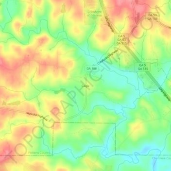
Name: Cagle topographic map, elevation, terrain.

Location: Cagle, Pickens County, Georgia, United States (34.37676 -84.45298 34.41676 -84.41298)

Average elevation: 1,184 ft

Minimum elevation: 1,033 ft

Maximum elevation: 1,342 ft

Pickens County trails, hiking, mountain biking, running and outdoor activities

Other topographic maps

Click on a map to view its topography, its elevation and its terrain.

Jasper

United States > Georgia > Pickens County > Jasper

Average elevation: 1,339 ft

Nelson

United States > Georgia > Pickens County

Average elevation: 1,227 ft

Jasper City Park

United States > Georgia > Pickens County > Jasper

Average elevation: 1,398 ft

Gear up for your next adventure:

🛶Inflatable Kayak - Portable kayak for rivers, lakes, and expeditions
🧴Hand Sanitizer - Keep hands clean while hiking
🧣Merino Neck Gaiters - Multi-functional headwear for wind and sun protection
🔌USB Car Charger - Car charger for on‑the‑go power needs
📚Navigation Handbooks - Master the art of reading topographic maps and using a compass

As an Amazon Associate, this site earns from qualifying purchases at no extra cost to you.