Geolocate

Alliance topographic map

Click on the map to display elevation.

About this map

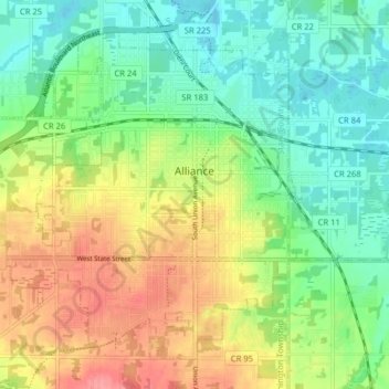
Name: Alliance topographic map, elevation, terrain.

Location: Alliance, Stark County, Ohio, United States (40.88620 -81.16257 40.93684 -81.08237)

Average elevation: 1,142 ft

Minimum elevation: 1,030 ft

Maximum elevation: 1,306 ft

Stark County trails, hiking, mountain biking, running and outdoor activities

Other topographic maps

Click on a map to view its topography, its elevation and its terrain.

Mount Pleasant

United States > Ohio > Stark County

Average elevation: 1,155 ft

Deer Creek

United States > Ohio > Stark County > Lexington

Average elevation: 1,047 ft

Sippo Heights

United States > Ohio > Stark County > Massillon

Average elevation: 1,043 ft

Lake Cable

United States > Ohio > Stark County

Average elevation: 1,115 ft

North Industry

United States > Ohio > Stark County

Average elevation: 1,093 ft

New Franklin

United States > Ohio > Stark County

Average elevation: 1,198 ft

Gear up for your next adventure:

🧯Portable Fire Pit - Compact fire pit for camping spots
🧭GPS Watch Accessories - Bands and chargers for GPS watches
🖼️Topo Map Wall Art - Decorative topographic prints of famous peaks and regions
🧦Hiking Socks - Comfortable socks to prevent blisters on long hikes
🧺Microfiber Travel Towels - Compact and fast-drying towels for trail use

As an Amazon Associate, this site earns from qualifying purchases at no extra cost to you.