
Make a donation
Gear up for your next adventure:
As an Amazon Associate, this site earns from qualifying purchases at no extra cost to you.
Kuusamo topographic map
Click on the map to display elevation.
Make a donation
Gear up for your next adventure:
As an Amazon Associate, this site earns from qualifying purchases at no extra cost to you.
Kuusamo
The city lies on a roughly 250-meter-high plateau, from which the waters flow in five directions. In the area of Kuusamo there are many hills (Finn. vaara) and fells (Finn. tunturi). The highest elevations are Valtavaara (492 m), Kuntivaara (481 m), Iivaara (469 m) and Rukatunturi (492 m), the site of the Ruka ski center.
Make a donation
Gear up for your next adventure:
As an Amazon Associate, this site earns from qualifying purchases at no extra cost to you.
About this map
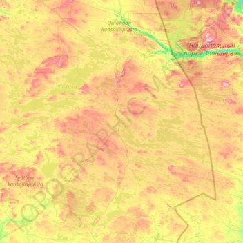
Name: Kuusamo topographic map, elevation, terrain.
Average elevation: 873 ft
Minimum elevation: 390 ft
Maximum elevation: 1,847 ft
Make a donation
Gear up for your next adventure:
As an Amazon Associate, this site earns from qualifying purchases at no extra cost to you.
Other topographic maps
Click on a map to view its topography, its elevation and its terrain.
Make a donation
Gear up for your next adventure:
As an Amazon Associate, this site earns from qualifying purchases at no extra cost to you.
Make a donation
Gear up for your next adventure:
As an Amazon Associate, this site earns from qualifying purchases at no extra cost to you.