Geolocate

Chandkhed topographic map

Click on the map to display elevation.

About this map

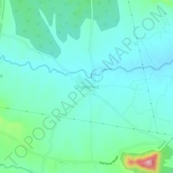
Name: Chandkhed topographic map, elevation, terrain.

Location: Chandkhed, Mawal, Pune, Maharashtra, India (18.62830 73.62882 18.66830 73.66882)

Average elevation: 2,031 ft

Minimum elevation: 1,900 ft

Maximum elevation: 2,602 ft

Other topographic maps

Click on a map to view its topography, its elevation and its terrain.

Tung Fort

India > Maharashtra > Mawal

Average elevation: 2,405 ft

Tikona Fort

India > Maharashtra > Mawal > Tikona Peth

Average elevation: 2,434 ft

Pavana Dam

India > Maharashtra > Mawal > Kale Colony

Average elevation: 2,001 ft

Kasarsai

India > Maharashtra > Mawal > Pachane

Average elevation: 2,146 ft

Patan

India > Maharashtra > Mawal

Average elevation: 2,260 ft

Patan

India > Maharashtra > Mawal

Average elevation: 2,260 ft

Gear up for your next adventure:

🛌Ultralight Sleeping Bags - Compact down bags for cold nights in the wilderness
🛡️Bear Spray Outdoor - Protection in bear country hikes
🛰️Handheld GPS Units - Professional satellite navigators for precise backcountry mapping
🧦Merino Wool Socks - Moisture-wicking, blister-preventing socks for long treks
🌄Hiking Binoculars - Compact binoculars for scenic views and trail spotting

As an Amazon Associate, this site earns from qualifying purchases at no extra cost to you.