Geolocate

Manston topographic map

Click on the map to display elevation.

About this map

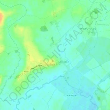
Name: Manston topographic map, elevation, terrain.

Location: Manston, Dorset, England, United Kingdom (50.92782 -2.29219 50.95390 -2.24423)

Average elevation: 167 ft

Minimum elevation: 138 ft

Maximum elevation: 233 ft

Other topographic maps

Click on a map to view its topography, its elevation and its terrain.

Fontmell Down

United Kingdom > England > Dorset > Fontmell Magna

Average elevation: 512 ft

Morcombelake

United Kingdom > England > Dorset

Average elevation: 243 ft

Wareham

United Kingdom > England > Dorset

Average elevation: 52 ft

St Ives

United Kingdom > England > Dorset

Average elevation: 79 ft

Muckleford

United Kingdom > England > Dorset > Grimstone

Average elevation: 374 ft

Burning Cliff

United Kingdom > England > Dorset > South Holworth

Average elevation: 210 ft

Ridge

United Kingdom > England > Dorset > Wareham > Ridge

Average elevation: 23 ft

Castletown

United Kingdom > England > Dorset

Average elevation: 59 ft

Mount Ararat

United Kingdom > England > Dorset > Verwood

Average elevation: 197 ft

Chiswell

United Kingdom > England > Dorset

Average elevation: 79 ft

Gear up for your next adventure:

🛡️Bear Spray Outdoor - Protection in bear country hikes
🧭Orienteering Set - Complete compass and map reading kit
🪶LED Camping Lantern - Bright lantern for camp lighting
🧥Men's Rain Shells - Premium waterproof and breathable jackets for mountain weather
🚑Emergency Bivvies - Heat-reflective sleeping bags for survival situations

As an Amazon Associate, this site earns from qualifying purchases at no extra cost to you.