
Make a donation
Gear up for your next adventure:
As an Amazon Associate, this site earns from qualifying purchases at no extra cost to you.
Tulare topographic map
Click on the map to display elevation.
Make a donation
Gear up for your next adventure:
As an Amazon Associate, this site earns from qualifying purchases at no extra cost to you.
About this map
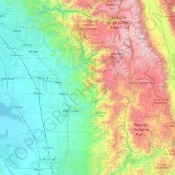
Name: Tulare topographic map, elevation, terrain.
Location: Tulare, Tulare County, Californie, États-Unis d'Amérique (35.55165 -119.55258 36.95165 -118.15258)
Average elevation: 3,802 ft
Minimum elevation: 177 ft
Maximum elevation: 14,285 ft
Make a donation
Gear up for your next adventure:
As an Amazon Associate, this site earns from qualifying purchases at no extra cost to you.
Other topographic maps
Click on a map to view its topography, its elevation and its terrain.
Spring Valley
États-Unis d'Amérique > Californie > San Diego County > Spring Valley
Average elevation: 584 ft
Make a donation
Gear up for your next adventure:
As an Amazon Associate, this site earns from qualifying purchases at no extra cost to you.
Make a donation
Gear up for your next adventure:
As an Amazon Associate, this site earns from qualifying purchases at no extra cost to you.
Make a donation
Gear up for your next adventure:
As an Amazon Associate, this site earns from qualifying purchases at no extra cost to you.
Make a donation
Gear up for your next adventure:
As an Amazon Associate, this site earns from qualifying purchases at no extra cost to you.
Contra Costa Rock
États-Unis d'Amérique > Californie > Comté d'Alameda > Berkeley
Average elevation: 371 ft
Make a donation
Gear up for your next adventure:
As an Amazon Associate, this site earns from qualifying purchases at no extra cost to you.
Morro Bay
États-Unis d'Amérique > Californie > San Luis Obispo County > Morro Bay
Average elevation: 177 ft
Rancho Cucamonga
États-Unis d'Amérique > Californie > San Bernardino County
Average elevation: 1,768 ft
Make a donation
Gear up for your next adventure:
As an Amazon Associate, this site earns from qualifying purchases at no extra cost to you.