Geolocate

Lanipga topographic map

Click on the map to display elevation.

About this map

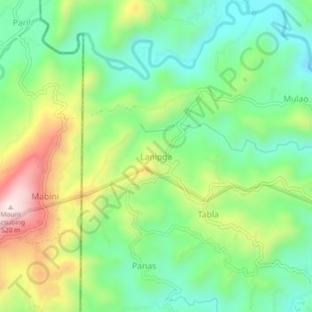
Name: Lanipga topographic map, elevation, terrain.

Location: Lanipga, Consolacion, Cebu, Central Visayas, Philippines (10.43779 123.91344 10.47779 123.95344)

Average elevation: 709 ft

Minimum elevation: 154 ft

Maximum elevation: 1,683 ft

Gear up for your next adventure:

🔌USB Car Charger - Car charger for on‑the‑go power needs
🌎3D Topographic Globes - Raised relief globes for a tactile understanding of geography
🔦Powerful Headlamps - Ultra-bright hands-free lighting for night navigation
🪄Magnetic Compass - Accurate compass for navigation
Camping Coffee Makers - Enjoy premium coffee at the summit or campsite

As an Amazon Associate, this site earns from qualifying purchases at no extra cost to you.