
Make a donation
Gear up for your next adventure:
As an Amazon Associate, this site earns from qualifying purchases at no extra cost to you.
Kappel topographic map
Click on the map to display elevation.
Make a donation
Gear up for your next adventure:
As an Amazon Associate, this site earns from qualifying purchases at no extra cost to you.
About this map
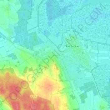
Name: Kappel topographic map, elevation, terrain.
Average elevation: 1,946 ft
Minimum elevation: 1,877 ft
Maximum elevation: 2,119 ft
Make a donation
Gear up for your next adventure:
As an Amazon Associate, this site earns from qualifying purchases at no extra cost to you.
Other topographic maps
Click on a map to view its topography, its elevation and its terrain.
Federsee
Deutschland > Baden-Württemberg > Landkreis Biberach > Bad Buchau
Ausgehend von der einstigen, von Karlhans Göttlich 1970/1972 festgestellten Grenzen der Moorfläche, weist das Becken nordöstlich einen (von der Seekante gemessenen) sechs Kilometer langen, zu Beginn drei Kilometer breiten, am Ende sehr schmalen (300 m) trichterförmigen Ausläufer auf, nordwestlich einen…
Average elevation: 1,903 ft