
Make a donation
Gear up for your next adventure:
As an Amazon Associate, this site earns from qualifying purchases at no extra cost to you.
Baldenweger Buck topographic map
Click on the map to display elevation.
Make a donation
Gear up for your next adventure:
As an Amazon Associate, this site earns from qualifying purchases at no extra cost to you.
Baldenweger Buck
Der kahle Rücken fällt nach Westen, Norden und Osten steil in die umgebenden Täler von Zastlerbach und Seebach ab. Lediglich nach Süden geht er mit geringem Höhenverlust in einen flachen, 1452,8 m hohen Sattel über, der den Baldenweger Buck mit dem Feldberggipfel verbindet.
Make a donation
Gear up for your next adventure:
As an Amazon Associate, this site earns from qualifying purchases at no extra cost to you.
About this map
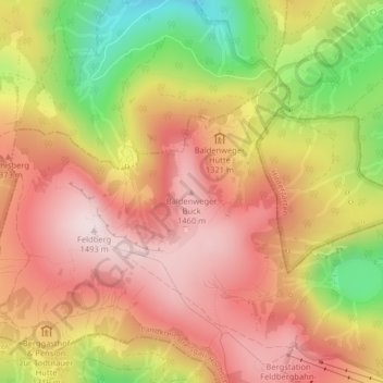
Name: Baldenweger Buck topographic map, elevation, terrain.
Average elevation: 4,232 ft
Minimum elevation: 3,205 ft
Maximum elevation: 4,908 ft
Make a donation
Gear up for your next adventure:
As an Amazon Associate, this site earns from qualifying purchases at no extra cost to you.