Geolocate

Whitmire topographic map

Click on the map to display elevation.

About this map

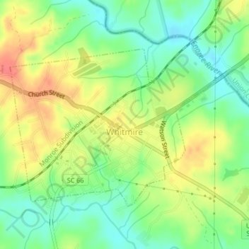
Name: Whitmire topographic map, elevation, terrain.

Location: Whitmire, Newberry County, South Carolina, United States (34.49485 -81.62661 34.51257 -81.59866)

Average elevation: 394 ft

Minimum elevation: 305 ft

Maximum elevation: 495 ft

Newberry County trails, hiking, mountain biking, running and outdoor activities

Other topographic maps

Click on a map to view its topography, its elevation and its terrain.

Scurry

United States > South Carolina > Newberry County

Average elevation: 512 ft

Mudlick

United States > South Carolina > Newberry County > Mudlick

Average elevation: 476 ft

Gear up for your next adventure:

📱Solar Portable Charger - Solar power bank for charging devices off‑grid
🧦Hiking Socks - Comfortable socks to prevent blisters on long hikes
🪶Survival Guide Book - Expert advice for emergency preparedness
🚑Emergency Bivvies - Heat-reflective sleeping bags for survival situations
🔭Compact Binoculars - HD vision for scouting terrain and identifying distant landmarks

As an Amazon Associate, this site earns from qualifying purchases at no extra cost to you.