Geolocate

Diplahan topographic map

Click on the map to display elevation.

About this map

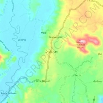
Name: Diplahan topographic map, elevation, terrain.

Location: Diplahan, Zamboanga Sibugay, Zamboanga Peninsula, Philippines (7.64930 122.94489 7.72930 123.02489)

Average elevation: 335 ft

Minimum elevation: 23 ft

Maximum elevation: 1,171 ft

Other topographic maps

Click on a map to view its topography, its elevation and its terrain.

Buluan Island

Philippines > Zamboanga Sibugay

Average elevation: 3 ft

Sibuguey River

Philippines > Zamboanga Sibugay

Average elevation: 784 ft

Gear up for your next adventure:

📻Weather Alert Radios - Stay informed of storm risks while off-the-grid
🪶Camping Sleeping Pad - Comfortable sleeping pad for backpacking
📷Action Cameras - Rugged cameras to document your journeys across rugged terrain
🧭Pro Hiking Compasses - High-accuracy liquid-filled compasses for topographic orientation
🏔️Mountain Trail Maps - High‑detail maps for popular peaks

As an Amazon Associate, this site earns from qualifying purchases at no extra cost to you.