
Make a donation
Gear up for your next adventure:
As an Amazon Associate, this site earns from qualifying purchases at no extra cost to you.
Port Byron topographic map
Click on the map to display elevation.
Make a donation
Gear up for your next adventure:
As an Amazon Associate, this site earns from qualifying purchases at no extra cost to you.
About this map
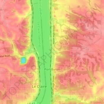
Name: Port Byron topographic map, elevation, terrain.
Location: Port Byron, Rock Island County, Illinois, United States (41.59065 -90.33787 41.63748 -90.30611)
Average elevation: 663 ft
Minimum elevation: 466 ft
Maximum elevation: 745 ft
Rock Island County trails, hiking, mountain biking, running and outdoor activities
Make a donation
Gear up for your next adventure:
As an Amazon Associate, this site earns from qualifying purchases at no extra cost to you.
Other topographic maps
Click on a map to view its topography, its elevation and its terrain.
Moline
United States > Illinois > Rock Island County > Moline
Moline witnessed a continued population increase after World War II with the completion of "Molette", a subdivision of mass-produced starter homes selling for $5,000 each. Molette was the first Moline neighborhood produced on a mass scale and one of the largest single-unit housing projects in the Midwest at…
Average elevation: 689 ft