
Make a donation
Gear up for your next adventure:
As an Amazon Associate, this site earns from qualifying purchases at no extra cost to you.
Ben Cat Town topographic map
Click on the map to display elevation.
Make a donation
Gear up for your next adventure:
As an Amazon Associate, this site earns from qualifying purchases at no extra cost to you.
Ben Cat Town
Ben Cat is in the transition zone from the Trường Sơn range in the north of the central highland to the southern plain, so the general topography of the whole town is relatively high from 30 to 35m above sea level in the north and lower to the south. In the south, the climate belongs to the tropical savanna region, there is little flooding and the average annual rainfall is about 1,500-2,500mm, the average monthly temperature is 32°C during the day and 23°C at night, the hottest month is 36 °C and the coldest month is 16°C. In mid-December, the town often has dense fog in the early morning and ends at 7-8am.
Make a donation
Gear up for your next adventure:
As an Amazon Associate, this site earns from qualifying purchases at no extra cost to you.
About this map
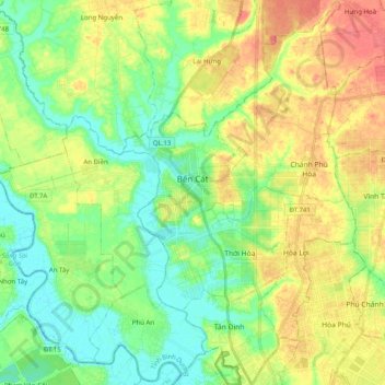
Name: Ben Cat Town topographic map, elevation, terrain.
Location: Ben Cat Town, Bình Dương Province, 75900, Vietnam (11.03422 106.50770 11.22963 106.69419)
Average elevation: 82 ft
Minimum elevation: -16 ft
Maximum elevation: 200 ft
Make a donation
Gear up for your next adventure:
As an Amazon Associate, this site earns from qualifying purchases at no extra cost to you.
Other topographic maps
Click on a map to view its topography, its elevation and its terrain.