Pattison topographic map
Interactive map
Click on the map to display elevation.
About this map
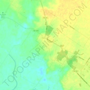
Name: Pattison topographic map, elevation, terrain.
Location: Pattison, Waller County, Texas, United States (29.80144 -96.00527 29.84088 -95.94491)
Average elevation: 151 ft
Minimum elevation: 105 ft
Maximum elevation: 194 ft
Other topographic maps
Click on a map to view its topography, its elevation and its terrain.
Monaville
United States > Texas > Waller County
Monaville, Waller County, Texas, United States
Average elevation: 177 ft
Pine Island
United States > Texas > Waller County > Pine Island
Pine Island, Waller County, Texas, United States
Average elevation: 210 ft
Prairie View
United States > Texas > Waller County
Prairie View, Waller County, Texas, 77446, United States
Average elevation: 259 ft
Hempstead
United States > Texas > Waller County
Hempstead, Waller County, Texas, 77445, United States
Average elevation: 226 ft
Brookshire
United States > Texas > Waller County
Brookshire, Waller County, Texas, United States
Average elevation: 161 ft
Brookshire
United States > Texas > Waller County > Brookshire > Brookshire
Brookshire, Waller County, Texas, 77423, United States
Average elevation: 154 ft