
Make a donation
Gear up for your next adventure:
As an Amazon Associate, this site earns from qualifying purchases at no extra cost to you.
Papagayo topographic map
Click on the map to display elevation.
Make a donation
Gear up for your next adventure:
As an Amazon Associate, this site earns from qualifying purchases at no extra cost to you.
About this map
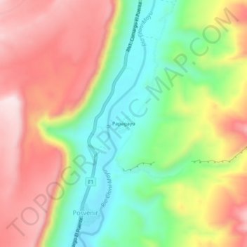
Name: Papagayo topographic map, elevation, terrain.
Average elevation: 8,386 ft
Minimum elevation: 7,723 ft
Maximum elevation: 9,094 ft
Make a donation
Gear up for your next adventure:
As an Amazon Associate, this site earns from qualifying purchases at no extra cost to you.
Other topographic maps
Click on a map to view its topography, its elevation and its terrain.
Camargo
Bolivia > Chuquisaca > Provincia Nor Cinti > Municipio Camargo
Camargo is the capital of Nor Cinti Province and is situated in Camargo Municipio, embedded between north-southerly mountain ridges, at an elevation of 2,414 m, on the banks of Río Chico which later becomes Río Pilaya.
Average elevation: 8,199 ft