
Make a donation
Gear up for your next adventure:
As an Amazon Associate, this site earns from qualifying purchases at no extra cost to you.
Camargo topographic map
Click on the map to display elevation.
Make a donation
Gear up for your next adventure:
As an Amazon Associate, this site earns from qualifying purchases at no extra cost to you.
Camargo
Camargo is the capital of Nor Cinti Province and is situated in Camargo Municipio, embedded between north-southerly mountain ridges, at an elevation of 2,414 m, on the banks of Río Chico which later becomes Río Pilaya.
Make a donation
Gear up for your next adventure:
As an Amazon Associate, this site earns from qualifying purchases at no extra cost to you.
About this map
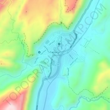
Name: Camargo topographic map, elevation, terrain.
Average elevation: 8,199 ft
Minimum elevation: 7,838 ft
Maximum elevation: 8,917 ft
Make a donation
Gear up for your next adventure:
As an Amazon Associate, this site earns from qualifying purchases at no extra cost to you.
Other topographic maps
Click on a map to view its topography, its elevation and its terrain.