
Make a donation
Gear up for your next adventure:
As an Amazon Associate, this site earns from qualifying purchases at no extra cost to you.
Panajachel topographic map
Click on the map to display elevation.
Make a donation
Gear up for your next adventure:
As an Amazon Associate, this site earns from qualifying purchases at no extra cost to you.
Panajachel
Panajachel (Spanish pronunciation: [panaxaˈtʃel], Pana) is a town in the southwestern Guatemalan Highlands, less than 140 kilometres (90 mi) from Guatemala City, in the department of Sololá. It serves as the administrative centre for the surrounding municipality of the same name. The elevation is 1,597 metres (5,240 ft). Population was 11 thousand in the 2000 census, projected as 15,830 by June 30, 2020 and has approximately doubled each of the last few decades. The town of Panajachel is located on the Northeast shore of Lake Atitlán, and has become a centre for the tourist trade of the area as it provides a base for visitors crossing the lake to visit other towns and villages.
Make a donation
Gear up for your next adventure:
As an Amazon Associate, this site earns from qualifying purchases at no extra cost to you.
About this map
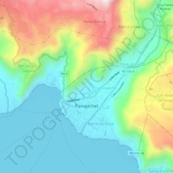
Name: Panajachel topographic map, elevation, terrain.
Location: Panajachel, Sololá, 07010, Guatemala (14.72725 -91.16406 14.76745 -91.11432)
Average elevation: 5,827 ft
Minimum elevation: 5,072 ft
Maximum elevation: 7,474 ft
Make a donation
Gear up for your next adventure:
As an Amazon Associate, this site earns from qualifying purchases at no extra cost to you.
Other topographic maps
Click on a map to view its topography, its elevation and its terrain.
Panajachel
Guatemala > Sololá > Panajachel > Panajachel
Panajachel (Spanish pronunciation: , Pana) is a town in the southwestern Guatemalan Highlands, less than 140 kilometres (90 mi) from Guatemala City, in the department of Sololá. It serves as the administrative centre for the surrounding municipality of the same name. The elevation is 1,597 metres (5,240 ft).…
Average elevation: 5,955 ft
Make a donation
Gear up for your next adventure:
As an Amazon Associate, this site earns from qualifying purchases at no extra cost to you.