
Make a donation
Gear up for your next adventure:
As an Amazon Associate, this site earns from qualifying purchases at no extra cost to you.
Kahler Asten topographic map
Click on the map to display elevation.
Make a donation
Gear up for your next adventure:
As an Amazon Associate, this site earns from qualifying purchases at no extra cost to you.
Kahler Asten
Der Kahle Asten bildet in der naturräumlichen Haupteinheitengruppe Süderbergland (Nr. 33) in der Haupteinheit Rothaargebirge (mit Hochsauerland) (333), in der Untereinheit Winterberger Hochland (333.5) und im Naturraum Astenberg (333.54) eine Singularität der 4. bis 7. Ordnung. Die Landschaft fällt nach Norden in den Naturraum Nordheller Höhen (333.57) ab, nach Nordosten in den Naturraum Harfeld (333.56), nach Osten in die Untereinheit Hohe Seite (333.7), nach Süden in den Naturraum Langewiese (333.53) und nach Südwesten bis Westen in die Untereinheit Lennekessel (333.6).
Make a donation
Gear up for your next adventure:
As an Amazon Associate, this site earns from qualifying purchases at no extra cost to you.
About this map
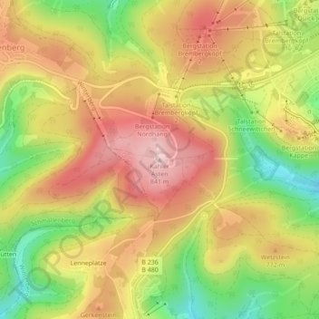
Name: Kahler Asten topographic map, elevation, terrain.
Average elevation: 2,431 ft
Minimum elevation: 2,014 ft
Maximum elevation: 2,769 ft
Make a donation
Gear up for your next adventure:
As an Amazon Associate, this site earns from qualifying purchases at no extra cost to you.
Other topographic maps
Click on a map to view its topography, its elevation and its terrain.
Neger
Deutschland > Nordrhein-Westfalen > Hochsauerlandkreis > Winterberg
Die Neger entspringt im Rothaargebirge an der Nordwestflanke des Klappersbergs (729,9 m) auf einer Höhe von 722 m ü. NHN im Naturschutzgebiet Hömberg / Brusenbecke / Eberg / Kalte Spring. Ihre Quelle liegt etwa 1,5 km (Luftlinie) nordöstlich von Rehsiepen, einem Ortsteil von Schmallenberg. Sie fließt…
Average elevation: 1,929 ft