
Thank you for supporting this site ❤️
Make a donation
Make a donation
Gear up for your next adventure:
As an Amazon Associate, this site earns from qualifying purchases at no extra cost to you.
Ōakura topographic map
Click on the map to display elevation.
Thank you for supporting this site ❤️
Make a donation
Make a donation
Gear up for your next adventure:
As an Amazon Associate, this site earns from qualifying purchases at no extra cost to you.
About this map
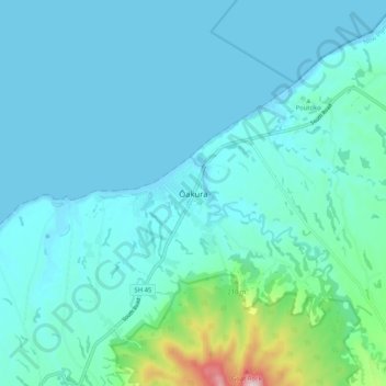
Name: Ōakura topographic map, elevation, terrain.
Location: Ōakura, New Plymouth District, Taranaki, 4314, New Zealand (-39.15753 173.91611 -39.07753 173.99611)
Average elevation: 243 ft
Minimum elevation: 0 ft
Maximum elevation: 1,985 ft
Thank you for supporting this site ❤️
Make a donation
Make a donation
Gear up for your next adventure:
As an Amazon Associate, this site earns from qualifying purchases at no extra cost to you.