
Make a donation
Gear up for your next adventure:
As an Amazon Associate, this site earns from qualifying purchases at no extra cost to you.
Mons-Bombaye topographic map
Click on the map to display elevation.
Make a donation
Gear up for your next adventure:
As an Amazon Associate, this site earns from qualifying purchases at no extra cost to you.
About this map
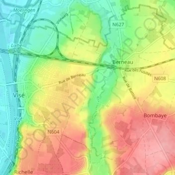
Name: Mons-Bombaye topographic map, elevation, terrain.
Location: Mons-Bombaye, Visé, Liège, Wallonie, 4600, Belgique (50.71650 5.69855 50.75650 5.73855)
Average elevation: 318 ft
Minimum elevation: 164 ft
Maximum elevation: 486 ft
Make a donation
Gear up for your next adventure:
As an Amazon Associate, this site earns from qualifying purchases at no extra cost to you.
Other topographic maps
Click on a map to view its topography, its elevation and its terrain.
Richelle
Belgique > Liège > Liège > Visé
Le village est situé en haut d'une falaise surplombant la Meuse de plusieurs dizaines de mètres. Le village est à une altitude approximative de 120 mètres, mais une toute petite partie du territoire du village court jusqu'à la Meuse, à ce moment à 60 mètres au-dessus du niveau de la mer.
Average elevation: 341 ft
Make a donation
Gear up for your next adventure:
As an Amazon Associate, this site earns from qualifying purchases at no extra cost to you.
Make a donation
Gear up for your next adventure:
As an Amazon Associate, this site earns from qualifying purchases at no extra cost to you.