Geolocate

Benton topographic map

Click on the map to display elevation.

About this map

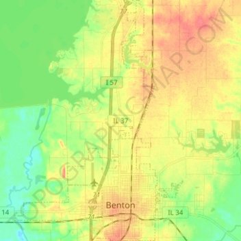
Name: Benton topographic map, elevation, terrain.

Location: Benton, Franklin County, Illinois, 62812, United States (37.98205 -88.94754 38.08010 -88.88784)

Average elevation: 433 ft

Minimum elevation: 354 ft

Maximum elevation: 512 ft

Franklin County trails, hiking, mountain biking, running and outdoor activities

Other topographic maps

Click on a map to view its topography, its elevation and its terrain.

Akin

United States > Illinois > Franklin County

Average elevation: 469 ft

Gear up for your next adventure:

🎁Geography Themed Gifts - Unique gift ideas for map lovers and geography enthusiasts
📦Gear Storage Bags - Organize and protect outdoor equipment
🖼️Topo Map Wall Art - Decorative topographic prints of famous peaks and regions
🧴Hand Sanitizer - Keep hands clean while hiking
🗺️Topographic Maps - Detailed topo maps for hiking, exploring and outdoor navigation

As an Amazon Associate, this site earns from qualifying purchases at no extra cost to you.