Geolocate

Corsano topographic map

Interactive map

Click on the map to display elevation.

About this map

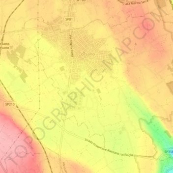
Name: Corsano topographic map, elevation, terrain.

Location: Corsano, Lecce, Pouilles, 73033, Italie (39.86744 18.35406 39.89779 18.39964)

Average elevation: 407 ft

Minimum elevation: 135 ft

Maximum elevation: 551 ft

Other topographic maps

Click on a map to view its topography, its elevation and its terrain.

Baia dei Turchi

Italie > Pouilles > Lecce > Otranto

Baia dei Turchi, Otranto, Lecce, Pouilles, Italie

Average elevation: 13 ft

Vernole

Italie > Pouilles > Lecce

Vernole, Lecce, Pouilles, 73029, Italie

Average elevation: 85 ft

Presicce-Acquarica

Italie > Pouilles > Lecce

Presicce-Acquarica, Lecce, Pouilles, Italie

Average elevation: 404 ft

Gallipoli

Italie > Pouilles > Lecce

Gallipoli, Lecce, Pouilles, 73014, Italie

Average elevation: 59 ft

Galatina

Italie > Pouilles > Lecce > Galatina

Galatina, Lecce, Pouilles, 73013, Italie

Average elevation: 226 ft

Otranto

Italie > Pouilles > Lecce

Otranto, Lecce, Pouilles, 73028, Italie

Average elevation: 82 ft