
Make a donation
Gear up for your next adventure:
As an Amazon Associate, this site earns from qualifying purchases at no extra cost to you.
Merzhausen topographic map
Click on the map to display elevation.
Make a donation
Gear up for your next adventure:
As an Amazon Associate, this site earns from qualifying purchases at no extra cost to you.
Merzhausen
Merzhausen liegt zwischen den Tälern der Weil und Usa am Nordhang des Stockberges im östlichen Hintertaunus. Der Höhenbolzen an der Westseite der evangelischen Kirche hat eine genaue Höhe von 439,575 m ü. NN. Die höchste Erhebung ist der Hirschberg mit 484,40 m ü. NN. Der tiefste Punkt in der Gemarkung ist die „Höll“ mit 350,00 m ü. NN. Die mittlere Höhe liegt bei 441 m.
Make a donation
Gear up for your next adventure:
As an Amazon Associate, this site earns from qualifying purchases at no extra cost to you.
About this map
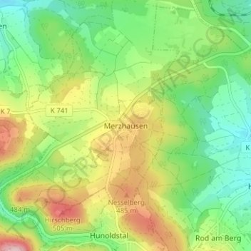
Name: Merzhausen topographic map, elevation, terrain.
Location: Merzhausen, Usingen, Hochtaunuskreis, Hessen, 61267, Deutschland (50.29794 8.44652 50.33794 8.48652)
Average elevation: 1,306 ft
Minimum elevation: 1,007 ft
Maximum elevation: 1,778 ft
Make a donation
Gear up for your next adventure:
As an Amazon Associate, this site earns from qualifying purchases at no extra cost to you.
Other topographic maps
Click on a map to view its topography, its elevation and its terrain.