
Make a donation
Gear up for your next adventure:
As an Amazon Associate, this site earns from qualifying purchases at no extra cost to you.
Old Stone Fort State Archaeological Park topographic map
Click on the map to display elevation.
Make a donation
Gear up for your next adventure:
As an Amazon Associate, this site earns from qualifying purchases at no extra cost to you.
Old Stone Fort State Archaeological Park
The Duck River system spills over a limestone-rich shelf of the western Cumberland Plateau known as the Highland Rim. As the Duck and Little Duck approach their convergence, they rapidly drop in elevation, and have cut relatively deep gorges around the peninsula upon which the ancient structure is located. Both gorges are highlighted by a series of substantial waterfalls and whitewater rapids. The natural waterpower in these two gorges attracted entrepreneurs and millwrights throughout the 19th century.
Make a donation
Gear up for your next adventure:
As an Amazon Associate, this site earns from qualifying purchases at no extra cost to you.
About this map
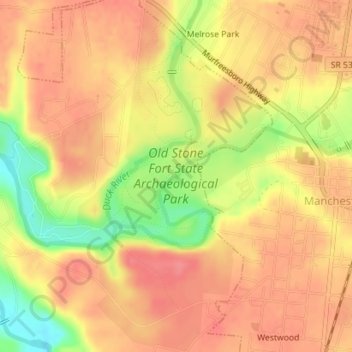
Name: Old Stone Fort State Archaeological Park topographic map, elevation, terrain.
Average elevation: 1,037 ft
Minimum elevation: 879 ft
Maximum elevation: 1,112 ft
Coffee County trails, hiking, mountain biking, running and outdoor activities
Make a donation
Gear up for your next adventure:
As an Amazon Associate, this site earns from qualifying purchases at no extra cost to you.
Other topographic maps
Click on a map to view its topography, its elevation and its terrain.
Royal Oaks
United States > Tennessee > Coffee County > Manchester > Royal Oaks
Average elevation: 1,070 ft
Make a donation
Gear up for your next adventure:
As an Amazon Associate, this site earns from qualifying purchases at no extra cost to you.