
Make a donation
Gear up for your next adventure:
As an Amazon Associate, this site earns from qualifying purchases at no extra cost to you.
Alhões topographic map
Click on the map to display elevation.
Make a donation
Gear up for your next adventure:
As an Amazon Associate, this site earns from qualifying purchases at no extra cost to you.
About this map
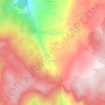
Name: Alhões topographic map, elevation, terrain.
Average elevation: 3,675 ft
Minimum elevation: 2,021 ft
Maximum elevation: 4,482 ft
Make a donation
Gear up for your next adventure:
As an Amazon Associate, this site earns from qualifying purchases at no extra cost to you.
Other topographic maps
Click on a map to view its topography, its elevation and its terrain.
Gralheira
Portugal > Viseu > Alhões, Bustelo, Gralheira e Ramires
Gralheira foi uma freguesia portuguesa do município de Cinfães, distrito de Viseu, situada em plena serra de Montemuro, com 10,19 km² de área e 165 habitantes (2011). Densidade: 16,2 hab/km². A elevada altitude da sede de freguesia (1103 m) torna-a uma das mais altas aldeias de Portugal, a par de Pitões…
Average elevation: 3,757 ft
Make a donation
Gear up for your next adventure:
As an Amazon Associate, this site earns from qualifying purchases at no extra cost to you.
Montemuro
Portugal > Viseu > Alhões, Bustelo, Gralheira e Ramires
A Serra de Montemuro é a oitava maior elevação de Portugal Continental, com 1382 metros de altitude. Situa-se nos concelhos de Arouca (distrito de Aveiro), Cinfães, Resende e Castro Daire e Lamego (distrito de Viseu) e entre as regiões do Douro Litoral e da Beira Alta.
Average elevation: 4,190 ft