
Thank you for supporting this site ❤️
Make a donation
Make a donation
Gear up for your next adventure:
As an Amazon Associate, this site earns from qualifying purchases at no extra cost to you.
Lötschental topographic map
Click on the map to display elevation.
Thank you for supporting this site ❤️
Make a donation
Make a donation
Gear up for your next adventure:
As an Amazon Associate, this site earns from qualifying purchases at no extra cost to you.
About this map
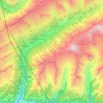
Name: Lötschental topographic map, elevation, terrain.
Location: Lötschental, Blatten, Westlich Raron, Wallis, 3919, Switzerland (46.32011 7.74402 46.45511 7.91816)
Average elevation: 7,280 ft
Minimum elevation: 2,316 ft
Maximum elevation: 12,822 ft
Thank you for supporting this site ❤️
Make a donation
Make a donation
Gear up for your next adventure:
As an Amazon Associate, this site earns from qualifying purchases at no extra cost to you.