
Thank you for supporting this site ❤️
Make a donation
Make a donation
Gear up for your next adventure:
As an Amazon Associate, this site earns from qualifying purchases at no extra cost to you.
Ostercappeln topographic map
Click on the map to display elevation.
Thank you for supporting this site ❤️
Make a donation
Make a donation
Gear up for your next adventure:
As an Amazon Associate, this site earns from qualifying purchases at no extra cost to you.
About this map
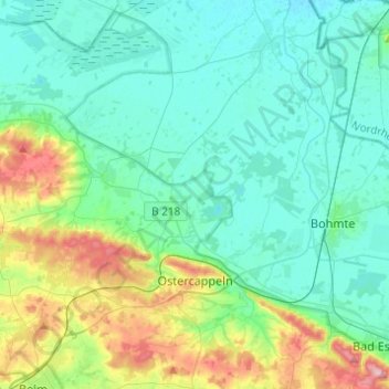
Name: Ostercappeln topographic map, elevation, terrain.
Location: Ostercappeln, Landkreis Osnabrück, Lower Saxony, 49179, Germany (52.30295 8.12568 52.45251 8.29626)
Average elevation: 233 ft
Minimum elevation: 125 ft
Maximum elevation: 623 ft
Thank you for supporting this site ❤️
Make a donation
Make a donation
Gear up for your next adventure:
As an Amazon Associate, this site earns from qualifying purchases at no extra cost to you.
Other topographic maps
Click on a map to view its topography, its elevation and its terrain.
Ahausen
Germany > Lower Saxony > Landkreis Osnabrück > Bersenbrück > Ahausen
Average elevation: 148 ft