
Chestertown topographic map
Click on the map to display elevation.
Chestertown
Chestertown is located at 43°39′09″N 073°48′03″W / 43.65250°N 73.80083°W / 43.65250; -73.80083 (43.6525664, -73.8009597) and its elevation is 896 feet (273 m). The ZIP code is 12817 and it is in the Eastern Time Zone. The nearest city is Glens Falls.
About this map
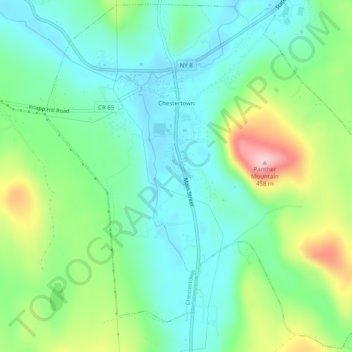
Name: Chestertown topographic map, elevation, terrain.
Average elevation: 1,007 ft
Minimum elevation: 801 ft
Maximum elevation: 1,490 ft
Warren County trails, hiking, mountain biking, running and outdoor activities
Other topographic maps
Click on a map to view its topography, its elevation and its terrain.
Big Bear Mountain
United States > New York > Warren County > Town of Johnsburg
Average elevation: 2,021 ft
French Mountain
United States > New York > Warren County > Town of Queensbury
Average elevation: 1,040 ft
Thirteenth Lake
United States > New York > Warren County > Town of Johnsburg
Average elevation: 1,962 ft
Windover Lake
United States > New York > Warren County > Town of Johnsburg
Average elevation: 1,634 ft
Moon Mountain
United States > New York > Warren County > Town of Warrensburg
Average elevation: 863 ft