Geolocate

Cueto topographic map

Click on the map to display elevation.

About this map

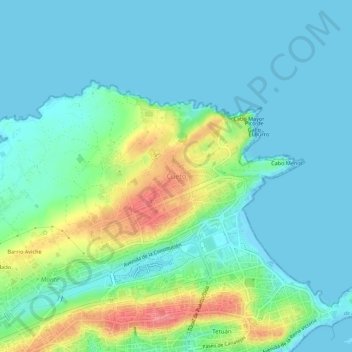
Name: Cueto topographic map, elevation, terrain.

Location: Cueto, Santander, Cantabria, 39012, Spain (43.46397 -3.81853 43.50397 -3.77853)

Average elevation: 66 ft

Minimum elevation: -7 ft

Maximum elevation: 266 ft

Gear up for your next adventure:

🚁Photography Drones - Capture stunning aerial views of landforms and topography
🔭Stargazing Telescopes - Perfect for camping in low-light pollution areas shown on maps
🪶Multi‑Purpose Knife - Useful blade for camp and trail
🔦Compact Flashlight - Reliable flashlight for emergencies
🗃️Trail First Aid Kit - Essential kit for outdoor injuries and emergencies

As an Amazon Associate, this site earns from qualifying purchases at no extra cost to you.