Geolocate

Wulvergem topographic map

Click on the map to display elevation.

About this map
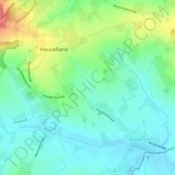
Name: Wulvergem topographic map, elevation, terrain.

Location: Wulvergem, Heuvelland, Ieper, West Flanders, Flanders, 8952, Belgium (50.75752 2.82409 50.77778 2.86074)

Average elevation: 148 ft

Minimum elevation: 75 ft

Maximum elevation: 253 ft

Other topographic maps

Click on a map to view its topography, its elevation and its terrain.
Polderhoek

Belgium > West Flanders > Ieper > Zonnebeke > Geluveld > Poezelhoek

Average elevation: 148 ft
Kemmelberg

Belgium > West Flanders > Ieper > Heuvelland

Average elevation: 223 ft

Rodeberg

Belgium > West Flanders > Ieper > Heuvelland

Average elevation: 269 ft

Gear up for your next adventure:

🌄Hiking Binoculars - Compact binoculars for scenic views and trail spotting
📱Heavy-Duty Phone Cases - Drop-proof and waterproof protection for outdoor navigation
🗺️Topographic Maps - Detailed topo maps for hiking, exploring and outdoor navigation
🧯Emergency Survival Kit - All‑in‑one survival essentials for the backcountry
🎁Geography Themed Gifts - Unique gift ideas for map lovers and geography enthusiasts

As an Amazon Associate, this site earns from qualifying purchases at no extra cost to you.