Geolocate

Wulvergem topographic map

Click on the map to display elevation.

About this map
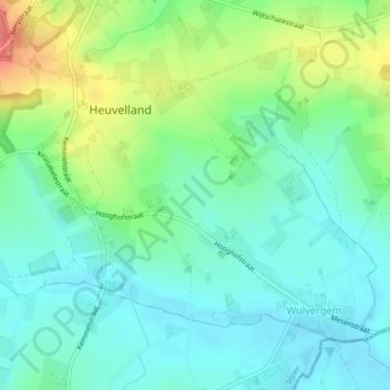
Name: Wulvergem topographic map, elevation, terrain.

Location: Wulvergem, Heuvelland, Ieper, West Flanders, Flanders, 8952, Belgium (50.75752 2.82409 50.77778 2.86074)

Average elevation: 148 ft

Minimum elevation: 75 ft

Maximum elevation: 253 ft

Other topographic maps

Click on a map to view its topography, its elevation and its terrain.
Polderhoek

Belgium > West Flanders > Ieper > Zonnebeke > Geluveld > Poezelhoek

Average elevation: 148 ft
Kemmelberg

Belgium > West Flanders > Ieper > Heuvelland

Average elevation: 223 ft

Rodeberg

Belgium > West Flanders > Ieper > Heuvelland

Average elevation: 269 ft

Gear up for your next adventure:

📷Action Camera - Capture your outdoor adventures in HD
🖼️Topo Map Wall Art - Decorative topographic prints of famous peaks and regions
🛠️Outdoor Gear Repair Kit - Essential tools to fix gear on the trail
👖Convertible Hiking Pants - Versatile zip-off pants for changing altitudes and temperatures
🎒Trekking Poles - Sturdy poles for balance and stability on rough terrain

As an Amazon Associate, this site earns from qualifying purchases at no extra cost to you.