
Bückeburg topographic map
Interactive map
Click on the map to display elevation.
About this map
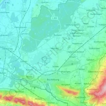
Name: Bückeburg topographic map, elevation, terrain.
Location: Bückeburg, Landkreis Schaumburg, Lower Saxony, 31675, Germany (52.23405 8.96332 52.35156 9.10163)
Average elevation: 233 ft
Minimum elevation: 115 ft
Maximum elevation: 889 ft
Other topographic maps
Click on a map to view its topography, its elevation and its terrain.
Rinteln
Germany > Lower Saxony > Landkreis Schaumburg > Rinteln > Rinteln
Rinteln, Landkreis Schaumburg, Lower Saxony, 31737, Germany
Average elevation: 331 ft
Rinteln
Germany > Lower Saxony > Landkreis Schaumburg
Rinteln, Landkreis Schaumburg, Lower Saxony, 31737, Germany
Average elevation: 499 ft