
Rinteln topographic map
Interactive map
Click on the map to display elevation.
About this map
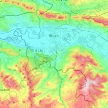
Name: Rinteln topographic map, elevation, terrain.
Location: Rinteln, Landkreis Schaumburg, Lower Saxony, 31737, Germany (52.09425 8.98588 52.22594 9.24780)
Average elevation: 499 ft
Minimum elevation: 154 ft
Maximum elevation: 1,253 ft
Other topographic maps
Click on a map to view its topography, its elevation and its terrain.
Bückeburg
Germany > Lower Saxony > Landkreis Schaumburg
Bückeburg, Landkreis Schaumburg, Lower Saxony, 31675, Germany
Average elevation: 233 ft
Rinteln
Germany > Lower Saxony > Landkreis Schaumburg > Rinteln > Rinteln
Rinteln, Landkreis Schaumburg, Lower Saxony, 31737, Germany
Average elevation: 331 ft