
Pitt Meadows topographic map
Click on the map to display elevation.
About this map
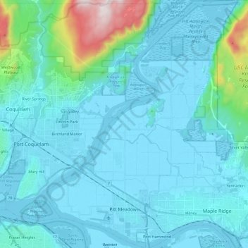
Name: Pitt Meadows topographic map, elevation, terrain.
Average elevation: 397 ft
Minimum elevation: -10 ft
Maximum elevation: 3,602 ft
Other topographic maps
Click on a map to view its topography, its elevation and its terrain.
Richmond
Canada > British Columbia > Metro Vancouver Regional District > Richmond
Average elevation: 49 ft
Burnaby
Canada > British Columbia > Metro Vancouver Regional District > Burnaby
Burnaby occupies 98.6 square kilometres (38.1 sq mi) and is located at the geographic centre of the Metro Vancouver area and home to the Metro Vancouver regional government in Metrotown. Situated between the city of Vancouver on the west and Port Moody, Coquitlam, and New Westminster on the east, Burnaby is…
Average elevation: 472 ft
Capilano Lake
Canada > British Columbia > Metro Vancouver Regional District > West Vancouver
Average elevation: 1,158 ft
Surrey
Canada > British Columbia > Metro Vancouver Regional District > Surrey
Average elevation: 213 ft
Mount Burwell
Canada > British Columbia > Metro Vancouver Regional District > Electoral Area A
Average elevation: 3,609 ft
New Westminster
Canada > British Columbia > Metro Vancouver Regional District
Average elevation: 285 ft
Institute Park
Canada > British Columbia > Metro Vancouver Regional District
Average elevation: 581 ft
Sugar Mountain
Canada > British Columbia > Metro Vancouver Regional District > Anmore
Average elevation: 591 ft
Maple Ridge
Canada > British Columbia > Metro Vancouver Regional District > Maple Ridge
Average elevation: 633 ft